
Menu
U.S. Highway 80 California Photo Tour
A day of driving U.S. 80 in California will give you a good sense of the climates, habitats, and cultures of California. You'll see sandy deserts, agricultural valleys, arid boulder-covered canyons, pine and oak scrub forests, chaparral, and an urban coastal city.
 The trip in California begins after crossing the historic 1915 Ocean-to-Ocean Highway truss bridge in Yuma, Arizona. The first town on the California side is Winterhaven. U.S. 80 passes the old Araz stage stop, crosses the All American Canal for the first time, and merges for a while with I-8.
 West of Sidewinder Road, U.S. 80 runs north of the freeway as a frontage road, passing the Center of the World monument. This road dates back to about 1932. The older pre-1932 alignment of U.S. 80 runs along parallel to the frontage road, a couple hundred feet to the north. This road dates back to 1915 and was the route first of the Southern National Highway, then later a number of early auto trails including the Bankhead Highway, the Lee Highway, the Dixie Overland Highway, and the Old Spanish Trail.
After Ogilby Road, U.S. 80 passes into the Algodones sand dunes. You'll feel like you're in the Sahara here. Some 6 or 7 miles of sand dunes gave early highway planners a real headache. Colonel Ed Fletcher, a San Diego leader and an officer on many auto trail associations, worked hard to get a direct road through the sand. The first attempt was a dual track plank road in 1915. Then a year later an 8 to 18 foot wooden plank road replaced this earlier difficult road across the dunes, with more stable sections in asphalt or oiled pavement. Much of Grays Well Road south of the freeway is old U.S. 80, and a display of old sections of the plank roads can be found to the west at Grays Well.
 Between the dunes and CA 115, the old highway is once again a frontage road on the north side of the road. This section can be quite rough, but you get a good look at a typical California creosote desert habitat. It's easy to spot NGS control markers and old State of California "C" blocks which mark the state's right of way. If you need to make some time though, this section is the one to skip. Take CA 115 northwest toward Holtville.
 Holtville is a nice little town with 80 running right through as its main street (5th). Holtville's pretty little park features an old So Cal Auto Club directional sign right next to the road. This was once right in the middle of the intersection!
From Holtville to El Centro the road passes through Imperial Valley agricultural land. The original auto trail evidently travelled on the north side of the tracks on Holton Rd.
 El Centro features two alignments of 80: 4th to Adams, and the older Main to Imperial to Adams. El Centro's main street has a very small town feel, with small shops and street lighting hanging from suspended cables across the road. You'll also pass the beautiful Imperial County court house building.
The road heads west through more agricultural land, and then returns to the desert. This time you enter a high desert scrub on the same path used by early emigrants and Spanish explorers taking the southern route to Los Angeles and San Francisco. West of the little town of Seeley and the Westside Main Canal you'll notice many gulleys crossed by timber and concrete bridges. Get out and take a look at these from underneath sometime. You don't see all that wood from up above. In this section you'll also notice the original concrete road on the south side of the road. Again, this dates as far back as 1915. You can actually drive a bit on this section, but be careful, there are no bridges. You go right down into the sand. Some sections also just break and drop off.


If you have some time to explore, and a good truck to do it in, take a drive on the road north to Painted Gorge. Geology professors take their classes here, and it's a really beautiful drive or walk up the canyon. You'll see lots of fossils and beautiful rock colors.
You'll pass the track of the Butterfield Stage and southern emigrant trail just before reaching Plaster City. This "city" is really just the US Gypsum plant where all your wallboard is made. The next civilized place is Ocotillo where you can get gas and food. Don't jump on the freeway right away, however. Instead take a bit of a detour west along old 80. Eventually the later road will veer to the left and will be buried under freeway lanes. At this point, the site of Miller's Station, you'll see the original cement concrete road shining in the sun, and heading straight west into the desert. Drive out on this until you come to a very obvious end. The road buckles and breaks off, washed away by desert flooding. Another old section lies up ahead.


After returning to the freeway, you'll be heading up the old, old wagon route in Devil's Canyon. U.S. 80 followed the eastbound lanes through In-Ko-Pah Gorge and Myer Creek. If you travel down hill heading east, you'll notice a great many old sections of early road, mostly on the west side. It's hard to sightsee here though, since you'll probably be barreling down the steep grade trying not to get run over on the freeway. Many of these sections can be visited on foot by hiking and boulder hopping along Myer Creek, back and forth under the freeway. Your friendly neighborhood Border Patrol will probably be watching your progress.
In any case, make sure to get off at the Mountain Springs exit to take a look at some nice sections of both the early auto trail route and later U.S. 80. The early road is narrow concrete, while the late road is asphalt paving. On the south (eastbound) side, at the site of the former Mountain Springs stop, you'll see the two roads crossing at the stop sign. To your immediate left, the old cement road breaks up while running right into the freeway lanes. It continues on the other side for a number of miles, and can be accessed from a dirt road between the east and westbound lanes. Also to your left, later U.S. 80 runs for a while, then dead ends as it goes under the eastbound lanes. In the other direction, the roads split and travel through private land up to the west end of the little valley.


Back on the freeway heading west, you come to Boulder Park at the In-Ko-Pah exit. Make sure to drive up to the Desert View Tower and take a look around, as you'll be driving on another old U.S. 80 section most of the way, and will get to see some other sections from the tower. North of the tower, a boulder climb will lead to another old cutoff loop of early roadway.
 You won't need to get back on the freeway for a while now, since you'll cross to the east side of the freeway, and travel southwest to the town of Jacumba. Keep and eye out on your left for old concrete sections of roadway. One appears not far down the road, before the turnoff to Jacumba. Another appears at a curve farther south.


 Jacumba was a major stop in the old days,
and even movie stars were seen here enjoying the hot springs
or eating at the
Barbara Worth Cafe. Take a little trip north to the old train station,
and check out the vintage passenger rail cars decaying near the wash.
Jacumba was a major stop in the old days,
and even movie stars were seen here enjoying the hot springs
or eating at the
Barbara Worth Cafe. Take a little trip north to the old train station,
and check out the vintage passenger rail cars decaying near the wash.
On the west side of Jacumba is a nice stretch of old concrete running right through a former service station and continuing on through fences and private property.


 After you cross the old San Diego and Arizona Railway tracks (often called the Impossible Railroad) and travel for a few miles, you'll spot another old stretch of concrete on the west side of the road. Next you'll come to Bankhead Springs, a little town actually named for the road you're on. One of the auto trails that 80 followed was the Bankhead Highway, named after Alabama U.S. Senator and Good Roads supporter John Hollis Bankhead.


Whatever you do, don't miss the old section coming up on your left as you turn west into the town of Boulevard. A short and narrow loop of original 15 foot road can be driven past the old Mistletoe Lodge (which sits on the south side). This is what the road was like when first built back in 1915, and you can see that quality does matter when it comes to road building.


 You'll pass through Boulevard, much of which has shifted west to what was once known as Manzanita or White Star. The Mexican restaurant on your left was once the post office of the original town of Boulevard, but most of the action now is farther west closer to the freeway exit.
On the left is the beginning of California highway 94 to Campo. This was the original route to San Diego, and the path of the earliest alignment of the Old Spansih Trail auto highway.
 A few miles west, the older road originally wound up into the hills, returning to the present route near La Posta Ranch. This was once a difficult stretch on the road to the coast. On the main road, you'll pass through the community of Live Oak Springs. Don't miss the little concrete spring on the south side of the road as you get closer to La Posta Ranch. Past the ranch is the little town of La Posta and the La Posta Diner. I always try to be here when I'm hungry! The food is great and the people are friendly. Let them know you're travelling the old road, and that you appreciate their small town business.
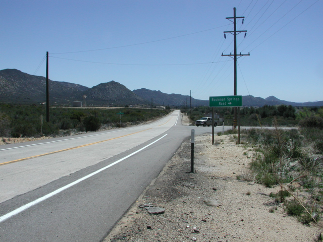
 The road passes by Boulder Oaks Campground, once the site of a nice little shop. You also pass the ghost town of Buckman Springs, with ruins and building slabs on both sides of the road.
At Laguna Junction, you'll cross I-8 and head west into the nice town of Pine Valley. There are places to eat and shop here, and a nice little county park right in the center of town.
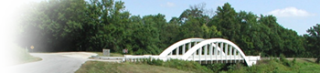
 Heading west you'll cross a 1928 bridge out of town. The road to the left (on the south side of the bridge) leads down to the old 1916 auto trail bridge, used by U.S. 80 for its first couple years.
The town of Guatay is next, followed by the road to Julian, and the road to Descanso at Descanso Junction. Just before reaching Wildwood Glen Lane, take note of an old section of concrete road on the west side. This once lead to the early Terrinitos bridge you'll see in a little while. Turn right and travel over the 1940s Sweetwater River bridge. Keep going and you'll soon be driving on original cement roadway. At the gate, get out and park your car. Take a walk down the old road on what is now a hiking route. Down the road on your right, you'll eventually come to an early U.S. 80 rest area, with a concrete tank and a series of basins below it. The road continues a ways farther until you come to a freeway fence. The road crossed here to the south side at the Vista Point. Return the way you came, but this time take a right onto the older alignment before you reach the later bridge. As you curve left, stop and look back the way you came, and you'll spot the old concrete heading to merge in with the later road. Continue on east and you'll cross the old Terrinitos bridge. This is definitely a photo opportunity.


At this point you'll have to reenter the I-8 for the last time. Head west, and leave the freeway at the next exit, East Willows Road. You're now travelling through the Viejas Indian Reservation. On the other side of the casino you pass through the little residential community of The Willows, and under the freeway. Head west and you'll enter Alpine. In town the road splits. The main later route of U.S. 80 heads west on Alpine Blvd. The old auto trail route, used by 80 in the 1920s went along Arnold Way. There are a few ellusive pieces of concrete in this stretch of road. Where the two roads merge once again, there's an old section of road up on the ridge on private land.
U.S. 80 goes back to the north side of the freeway, then to the south again. On the south side of the road is Mary Etta's Cafe, on the eastern end of Flinn Springs. From this point, the early road wound around quite a bit, but the later road follows its current path west to Lake Jennings Park Road.
 On the other side of the freeway, U.S. 80 follows I-8 business loop into El Cajon. Past the area known as Johnstown, you may spot another old section of concrete on the south side of the road near Montijo Wood Arts.
At Broadway, the early road turned west on a path through Bostonia. The later road continues on, however, straight onto Main Street in El Cajon.
The road bends left onto what was once San Diego Avenue, but is now called El Cajon Blvd. As you approach I-8 you can either enter the freeway west to La Mesa, or take a winding path that will let you enter La Mesa straight onto old 80. Most of the road was buried by the freeway in this section.
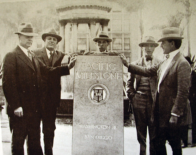
La Mesa has a nice downtown area. Make sure to stop for a while and check things out. The old rail depot, and trains on display there, are near the tracks off Spring Street. Beyond La Mesa, 80 passes through areas once called La Mesa Townsite and East San Diego. At Euclid, the road went south to University until 1926. From here it travelled all the way into Hillcrest and down 4th into downtown. The old auto trails had their end at Horton Plaza park in front of the U.S. Grant Hotel. You can still visit the Pacific Milestone, and its tribute to the Lee Highway, the Old Spanish Trail, and Ed Fletcher in the park. There's also a plaque marking the end of the Jefferson Davis Highway, and a bell marking the path of California's El Camino Real. The little park is really a must see for old road enthusiasts.

NOTE: The Pacific Milestone was moved to its original location east of the Gill fountain when renovation occurred in the front of Horton Plaza. The Jefferson Davis Highway terminus plaque was removed during the national push to remove Confederate monuments.

U.S. 80 follows El Cajon Blvd west to Park. Along El Cajon Blvd you'll see the historic Lafayette Hotel, where the rooms are named for the many movie stars who stayed there. The pool was designed by Tarzan star and Olympic medalist Johnny Weissmuller. The Mississippi Room downstairs features a wooden floor and a real shell for the band. Attached to the Lafayette is the Red Fox Room Restaurant, a classic American steakhouse.


Down the road you pass under the big "Boulevard" sign telling you you're on what was once the main road into San Diego. Early U.S. 80 turns left onto Park. Later, Washington Blvd was built west from here to carry U.S. 80 to the scenic Cabrillo Freeway, from where it traveled into downtown cosigned with U.S. 395.


 At Park you'll see the site of the old San Diego State Teachers College (forerunner of SDSU), now the location of a school and the San Diego Unified School District offices. To the right is the growing community of University Heights. Old U.S. 80 turns left and heads down Park.
At University, you're on the edge of the Hillcrest community. The old auto trails headed down University from East San Diego, then turned down 4th in the heart of Hillcrest for the trip into downtown. The Georgia Street bridge and underpass was created to allow street cars to go down University to East San Diego. Here you're looking east and west from the top of the bridge.


South of Park, you'll spot several examples of Egyptian Art Deco architecture including the newly erected "Egyptian" on the corner that copies the style of the older buildings.


The apartment and shop buildings on the east and west side of Park Blvd south of University are in the Egyptian Revival style. Many of the buildings along Park near Robinson St. were originally built in an Egyptian style, and traces remain even in buildings that have been remodeled. The origin of this style in San Diego was due to the popularity of the discoveries made in King Tutankhamen's tomb between 1922 and 1932.


U.S. 80 makes a jog to the west, and passes the Balboa Park Inn just before entering Balboa Park.


Soon you'll pass the world famous San Diego Zoo. Now you're in beautiful Balboa Park, the site of Panama-California Expostion of 1915, and the California-Pacific International Expostion of 1935. Balboa Park is where you'll find most of San Diego's museums, including (among many others) the Natural History Museum, the Museum of San Diego History, the Model Railroad Museum, and the Automotive Museum. The park is also known for its gardens, thanks mostly to Kate Sessions. There's an enormous Morton Bay Fig, a rose garden, a cactus and desert plant garden, a botanical building, a jungle-like palm canyon, and beautiful specimen trees all over the park.


You'll have to jog left to 13th to continue on south, as Park becomes one way north. (That chinese restaurant is pretty good, by the way.) Park Blvd south of "C" street is a crazy place. You share the road with the trolley line. The north side is one way north, the center is two-way for a few blocks, and the south side is one-way south. You can get back on Park at "E" if you're heading south to Market, but you may just want to stay on 13th. Northbound, you should be OK on Park. Early U.S. 80 seems to have gone into town on Broadway to terminate at Horton Plaza (see above). Later, however, it went south on Park to Market, and on west to end at the Pacific Highway, former U.S. 101 (now an historic route in its own right).


As I've already said, U.S. 80 later followed Washington Street and the Cabrillo Freeway (now CA 163) into downtown.
The final alignment of 80 went down the Alvarado Freeway (now I-8) to meet up with U.S. 101 at the current I-5/I-8 interchange near Old Town.
California Legislative Route No. 12 (which U.S. 80 follows from Pacific Highway all the way east to El Centro and which appears on all the official state transportation maps) actually keeps going all the way to the end of Point Loma and Cabrillo National Monument. This was probably never actually signed as U.S. 80 (it was California 209), but if you've come all the way from Tybee Island, I say go for it. Enjoy some tide pooling and whale watching for the end of your journey.