- Welcome to American Roads Forum.

Recent posts
#91
Old Spanish Trail / Re: OST better than florida 98...
Last post by rebar - April 14, 2013, 07:42:11 AMWow thanks Parsa.
Everything you've shown me looks interesting but unfortunately I only have 5 days Melbourne Fl to Iowa. I need to pick maybe ten points of interest, and visit them from the highway or interstate instead of driving the entire route. One of them being the new Madrid seismic zone. Fascinating knowing the Mississippi flowed backwards there.
Another interest of mine are the conquistador's who explored this region.
So Iv got some research and picking to do since I leave the 16th..
#92
Old Spanish Trail / Re: OST better than florida 98...
Last post by Parsa - April 13, 2013, 05:34:50 PMWelcome to the forum.
I would recommend looking at John Murphey's website. He no longer maintains it, but he's still active in promoting the OST. His email is on the bottom of the home page. Look at the pages for the states you want to drive. He can likely tell you about some interesting hotels along the way.
Drive the OST
If you look at my virtual road trips and the galleries (like the one you linked to), that will also show you some interesting places to see. Keep in mind that the Gulf Coast area of the OST changed a lot during just a few years due to reroutings as bridges were built, replacing ferries.
Florida road trip, Florida gallery
Alabama road trip, Alabama gallery
Mississippi road trip, Mississippi gallery
Louisiana road trip, Louisiana gallery
If you do take the OST, I'd recommend trying to follow the Mississippi River Scenic Highway (MRSH) north to Iowa. This is one of the old auto trails on my To Do list. It dates to 1919. As far as I know, nobody has researched this route, but I could provide maps of the general route if you want to explore. It had several branches in the south, so you could leave the OST at Mobile, AL and follow the branch northwest to Clarksdale and Coahoma, Mississippi (to meet the main trail), or you could follow the OST all the way to New Orleans and follow the main path of the MRSH north to eastern Iowa.
An auto trail called the Glacier Trail originally linked Glacier National Park in Montana with St. Louis. This highway was theoretically extended west to Washington State and southeast to the east Florida coast. I have one single map showing this longer version of the trail. It seems to be following the much more documented Bee Line Highway, which branched off the OST in Cottondale, FL, and went up through Alabama to Birmingham. There were then two branches, an east and a west, that both went to St. Louis to connect with the original route. The highway goes northwest in Missouri to head northwards in Iowa through Ottumwa, Oskaloosa, Grinnell, Marshalltown, Iowa Falls, and Mason City to Minnesota.
Here's a short web site from Iowa DOT about this trail.
#93
Old Spanish Trail / OST better than florida 98?
Last post by rebar - April 13, 2013, 08:57:09 AM I'm driving from Melbourne Fl to Iowa and have decided to drive the coasts. I was told in order to really to see and taste old Florida, I should consider driving the Old Spanish Trail. Sounds intriguing, but its route takes me away from the ocean and would take allot longer to drive.
http://www.americanroads.us/photos/OSTFLsummer2008/index.html
Can anyone recommend must see sections of the OST from Florida to Louisiana please? Or must eat at places?
I'll then follow the Mississippi north to New Madrid MO and on to Iowa.
Thanks
http://www.americanroads.us/photos/OSTFLsummer2008/index.html
Can anyone recommend must see sections of the OST from Florida to Louisiana please? Or must eat at places?
I'll then follow the Mississippi north to New Madrid MO and on to Iowa.
Thanks
#94
Bankhead Highway / Re: Bankhead route in Arkansas
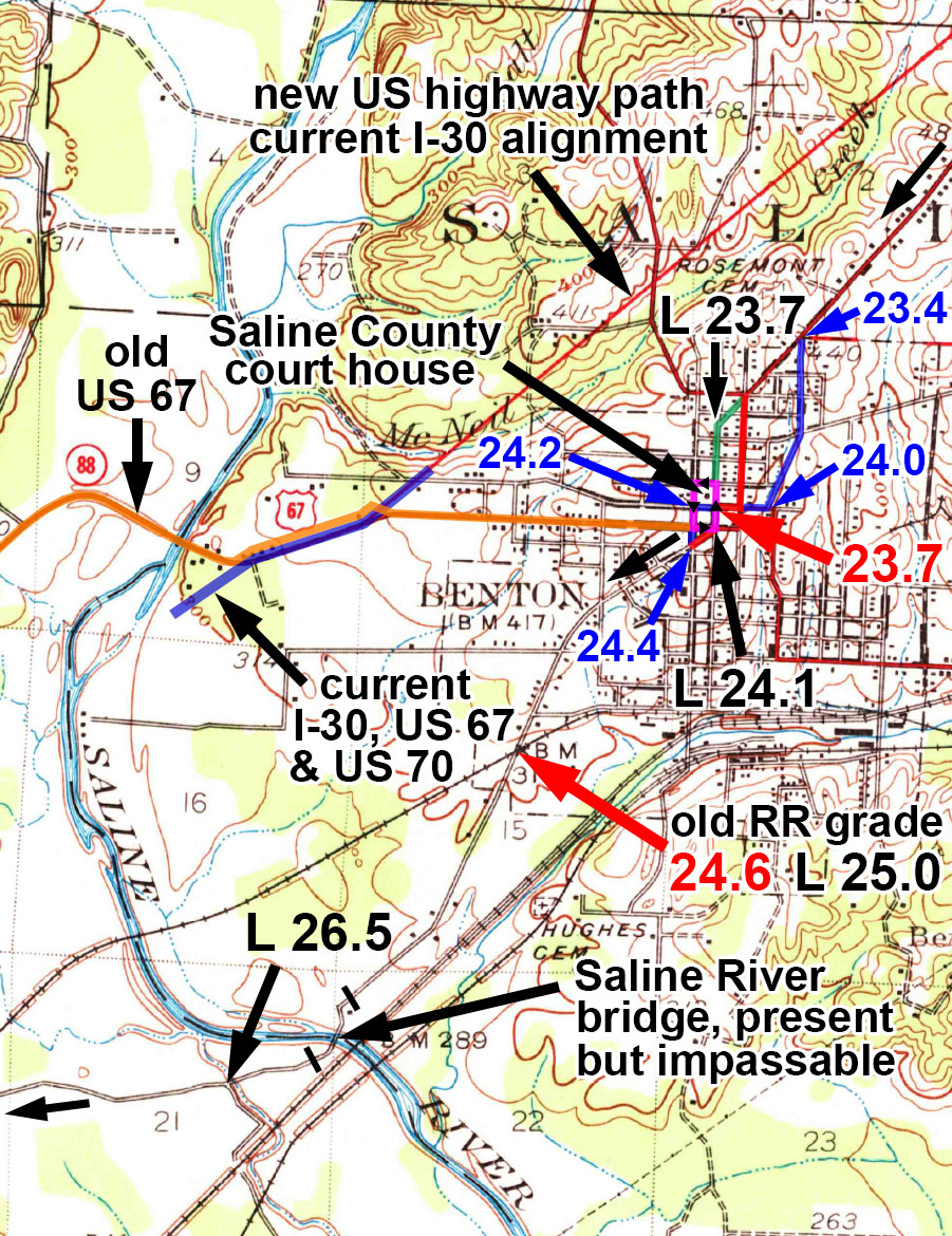
Last post by Parsa - April 07, 2013, 03:46:21 PMMap number 20.
This is from the 1938 Benton 15-minute quad (1:62500 version). Another 1938 quad exists at a scale of 1:48000. The latter map is much harder to read, however.
The map shows the area in the vicinity of Benton, AR.
There are multiple routes shown through Benton.
The Bankhead enters the area from the northeast along Military Road.
• The red route is that of the Dunn guide. It turns south along East Street, goes west on Sevier Street to the court house square, turns south on Main Street (no longer possible as it's one way), then jogs west a very short way on South Street to meet River Road.
• The green route shows the path of the Locke guide. It continued past East Street along Military Road until its end at Main Street. It then turned south on Main Street, past the court house, and also jogged west on South Street to River Road.
• The blue route shows the route used by the Automobile Blue Book of 1923. This one is odd in that it turns south on Lillian Street until its end at Sevier Street. It then heads west to the southwest corner of the court house square ("far side of courthouse"), and then turns south on Market Street. It continues south on Market until the junction with River Road, which it also follows southwest. This route has no obstacles due to one way streets.
• The court house square two-block perimeter is one way counter-clockwise (anti-clockwise). It is shown as a magenta line.
Unfortunately, the old Saline River bridge is out, and the Bankhead route is discontinuous here. Two long spurs exist on each side of the river, both called River Road. The railroad crossing southwest of town is no longer in use, but the RR crossing signs still exist. Evidently, there was a southerly-bound road just west of the river bridge. Traces of this road still exist, including a railroad underpass, but it no longer seems to be a through road.
Since the Bankhead Highway path no longer goes through, a detour, shown as an orange line, should be taken west along what was once US 67. This follows South Street west, crosses I-30 on the overpass, and continues along South Street southwesterly until the junction with Arkansas State Route 229. AR 229 was the original path of US 67 and old AR 88 as well. Follow this across the Saline River. The road will bend south and cross under I-30, becoming US 67 once more. Procede southwest along US 67 to the junction with River Road (on the east) and Pawnee Road (on the west). These are both the Bankhead Highway.
Red = Dunn guide. Blue = Auto Blue Book 1923. Black mileage = Locke guide.
#95
Bankhead Highway / Re: Bankhead route in Arkansas
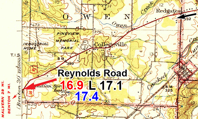
Last post by Parsa - April 05, 2013, 01:38:23 PMMap number 19.
This is from the 1938 Benton 15-minute quad (1:62500).
The map shows the area northeast of Benton, AR.
Red = Dunn guide. Black mileage = Locke guide.
This is from the 1938 Benton 15-minute quad (1:62500).
The map shows the area northeast of Benton, AR.
Red = Dunn guide. Black mileage = Locke guide.
#96
Bankhead Highway / Re: Bankhead route in Arkansas
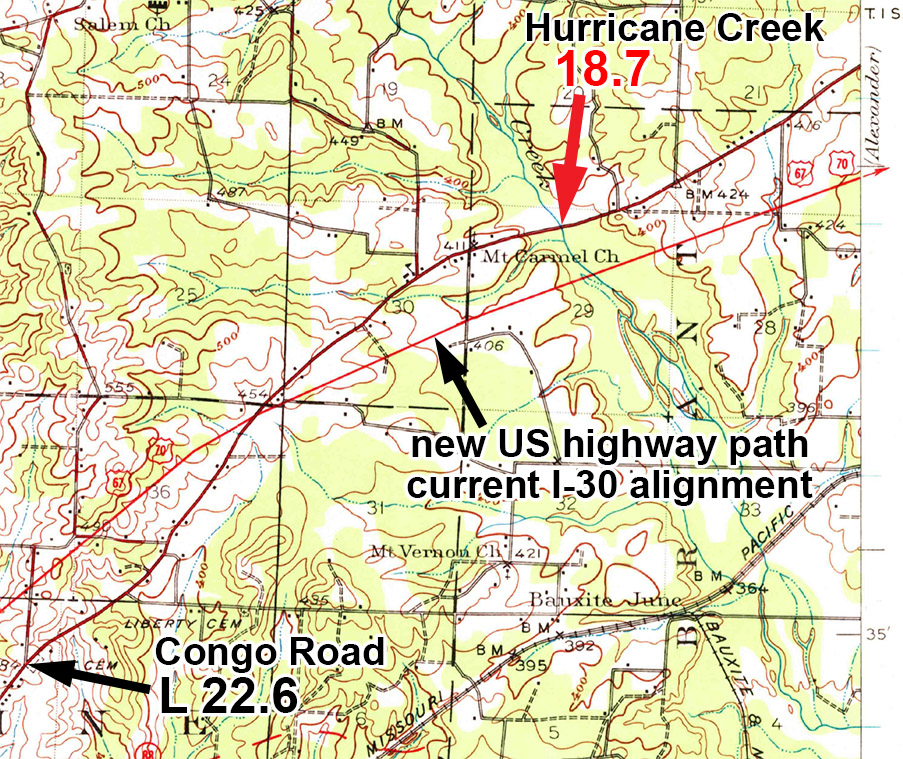
Last post by Parsa - April 03, 2013, 09:43:10 PMMap number 18.
This is from the 1941 Alexander 15-minute quad.
The map shows the area north of Bryant between Little Rock, AR and Benton, AR.
Red = Dunn guide. Blue = Auto Blue Book 1923. Black mileage = Locke guide.
This is from the 1941 Alexander 15-minute quad.
The map shows the area north of Bryant between Little Rock, AR and Benton, AR.
Red = Dunn guide. Blue = Auto Blue Book 1923. Black mileage = Locke guide.
#97
Bankhead Highway / Re: Bankhead route in Arkansas
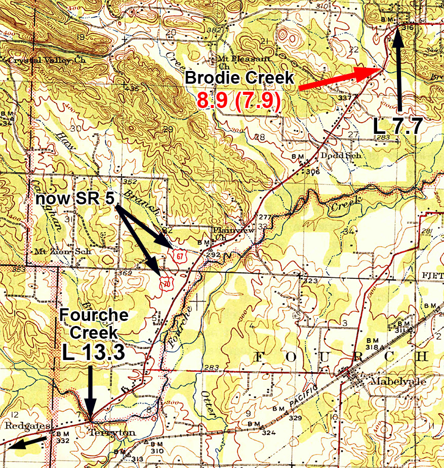
Last post by Parsa - March 29, 2013, 06:45:57 PMMap number 17.
This is from the 1941 Alexander 15-minute quad. It is oriented normally, with north at the top. There are three different 15-minute topos that were surveyed from 1934-35. I chose the 1941 edition because it has the road in red, has better contrast, and therefore is much clearer. The regular 1935 edition is almost identical, but none of the roads are shown in color, which makes them hard to see. Only the contour lines are really clear. A slightly older map, also likely from 1935 was evidently a provisional map. It does not include the northeast quadrant at all, because that section is covered by the Little Rock 7.5-minute map. The scale is 1:48000 on this map, but it shows no more detail than the other two. It is also difficult to see the road on this one.
The map shows the area southwest of the Little Rock, AR region.
There seems to be an error in the mileage of the Dunn guide at Brodie Creek. This is the only substantial bridge and creek west of Rock Creek, and the mileage for it would be exactly on 7.9 miles. I believe the 8.9 mileage given is a typographical error for the bridge, and the error exists for the opposite direction mileage also. It could possibly be McHenry Creek, but that is well beyond 8.9 miles, and much closer to Fourche Creek than the map indicates.
Red = Dunn guide. Black mileage = Locke guide.
#98
General U.S. Highway Topics / Re: great site
Last post by Parsa - March 26, 2013, 07:19:23 PMYes, it's a very interesting site. It does, however, give the ends as they exist today, not as they were when there were no interstate highways. So, US 80 ends near Dallas for example, rather than in San Diego as it once did.
Steve
Steve
#99
General U.S. Highway Topics / great site
Last post by Sam Pembroke - March 26, 2013, 02:48:06 PM #100
General U.S. Highway Topics / Re: Maps for the old US Routes
Last post by Sam Pembroke - March 25, 2013, 05:48:15 PMIn one of my Route 66 guidebooks by Tom Snyder he shows the interstates along the highway. Rittenhouse's guidebook to 66 doesn't show detailed maps, but has great descriptions of the route.