- Welcome to American Roads Forum.

Recent posts
#11
El Camino Real in California / Re: ECR — La Jolla to Del Mar
Last post by Parsa - July 02, 2015, 05:24:07 PMThis first map is a circa 1898 official San Diego County map. The La Jolla area was part of the former San Diego mission lands (San Diego Pueblo), and was called Ex Mission. Click for larger image.
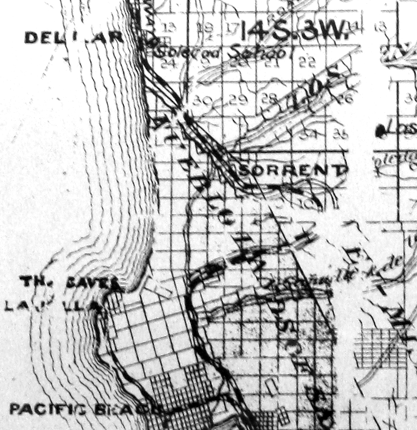
NOTES: The railroads seem to be shown with black and white striping. I believe the double line paths are the roads. Rail lines exist to La Jolla and up Rose Canyon. The La Jolla line was the San Diego, Pacific Beach & La Jolla Railway. The main tracks going north through Rose Canyon are the Santa Fe railroad. No continuous road seems to pass through La Jolla. The Rose Canyon road parallels the Santa Fe, and has several branches heading east. The big loop has a short cut road that is likely ECR. There is a major junction at Sorrento Siding, where a road heads northeast through Los Peñasquitos Rancho lands. A road that is evidently ECR continues northwest along the tracks, then heads north along the township line about 1.25 miles east of Del Mar. This road continues north to "San Dieguito" site off the map to the north.
NOTES: The railroads seem to be shown with black and white striping. I believe the double line paths are the roads. Rail lines exist to La Jolla and up Rose Canyon. The La Jolla line was the San Diego, Pacific Beach & La Jolla Railway. The main tracks going north through Rose Canyon are the Santa Fe railroad. No continuous road seems to pass through La Jolla. The Rose Canyon road parallels the Santa Fe, and has several branches heading east. The big loop has a short cut road that is likely ECR. There is a major junction at Sorrento Siding, where a road heads northeast through Los Peñasquitos Rancho lands. A road that is evidently ECR continues northwest along the tracks, then heads north along the township line about 1.25 miles east of Del Mar. This road continues north to "San Dieguito" site off the map to the north.
#12
El Camino Real in California / ECR — La Jolla to Del Mar
Last post by Parsa - July 02, 2015, 02:13:50 PMThe actual route of El Camino Real as defined by the El Camino Real Association in the first decade of the 20th century is a bit hard to pin down. Mrs. Harrie Forbes (creator of the ECR bells) in her book California Missions and Landmarks: El Camino Real says that the ECR went through Rose Canyon, not around through Pacific Beach and La Jolla. However, all auto club route books and strip maps show this coast route path as the main traveled road. This thread examines the maps and possible route of the ECR and the early coast route, circa 1900-1920.
#13
AmericanRoads.us Web Site / Re: Automobile Club of Souther...
Last post by Parsa - February 01, 2015, 03:14:46 PMI've updated the list to include a few maps that I don't own as well as flat maps (non-strip maps) that have map file numbers.
Steve
Steve
#14
General Auto Trail Topics / The relationship of old trails...
Last post by Carnut - August 26, 2014, 07:26:09 PMEveryone is familiar with our highways often flanking rail lines and telephone/telegraph lines existing between them. In Michigan, Virginia, and probably many states there are roads named "Telegraph Road." Some of them later became U.S. Highways or parts of U.S. Highways. An 1866 act of Congress granted telegraph companies access and easement across public lands and along Postal Roads however whether any of their construction and maintenance roads became any of the named seems to be without any specific mention. It would be interesting to know just how many of those roads actually became a part of our highway system.
#15
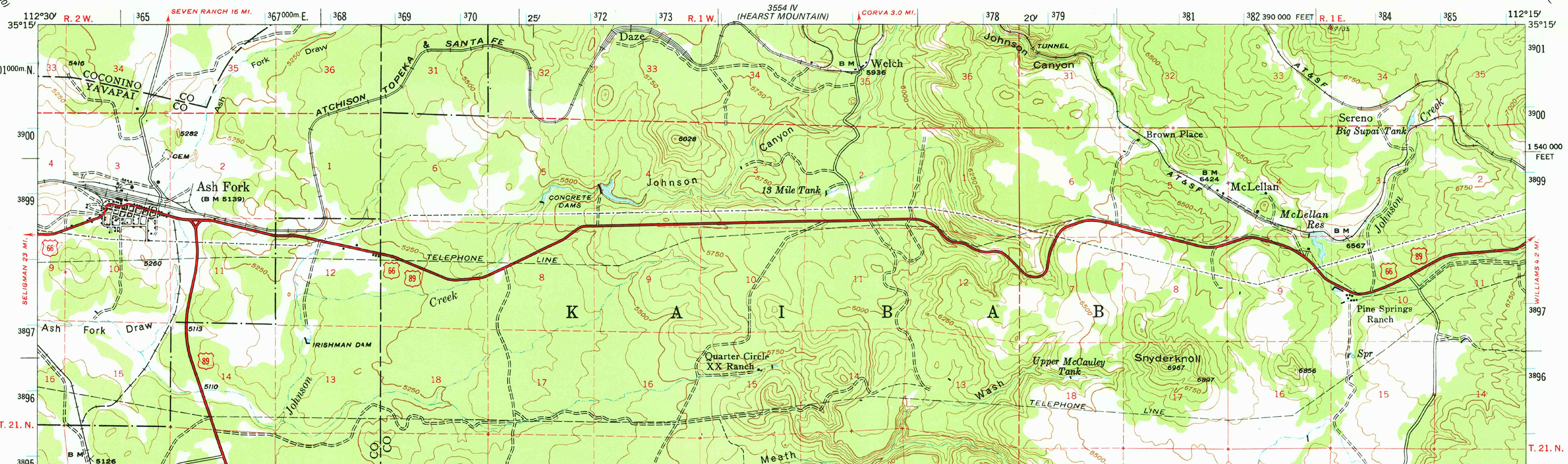
National Old Trails Road / Re: Williams to Kingman, Arizo...
Last post by Parsa - May 09, 2014, 07:13:21 PMThe map below is from the 1947 USGS 15-minute Ash Fork quadrangle.
— click for larger view —
— click for larger view —
#16
National Old Trails Road / Re: Williams to Kingman, Arizo...
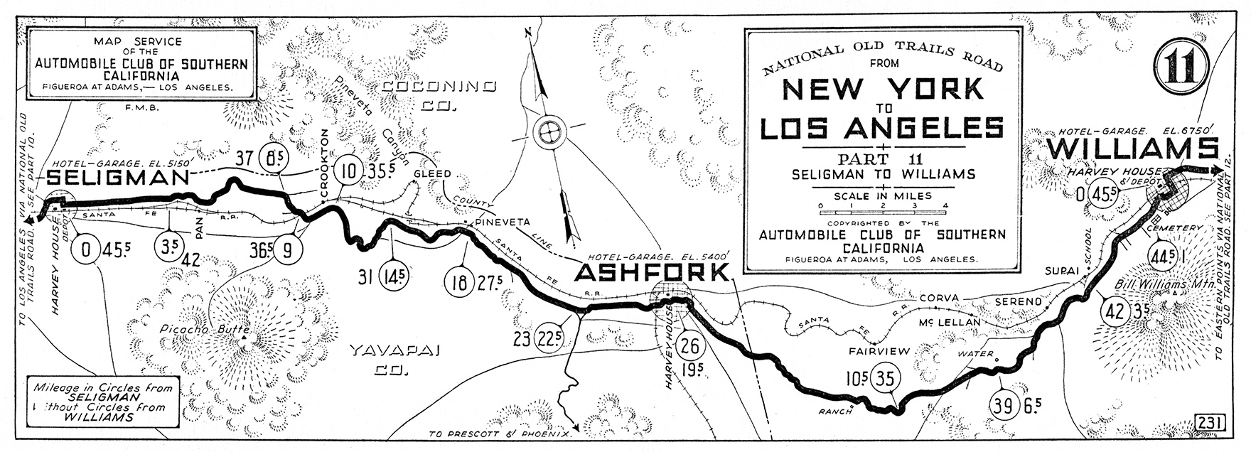
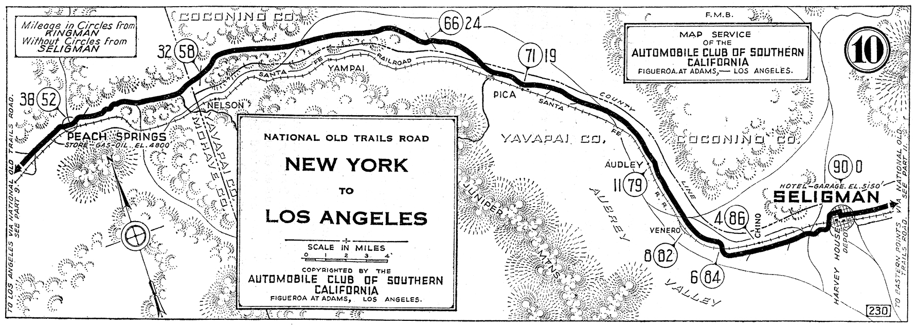
Last post by Parsa - May 09, 2014, 06:55:09 PMThese is are the maps from the 1923 Automobile Club of Southern California NOTR guide and from individual strip map cards for the early to mid 1920s.
This is ACSC map #231 from Williams, Arizona to Seligman.
— click for larger view —
This is ACSC map #230 from Seligman, Arizona to Peach Springs.
— click for larger view —
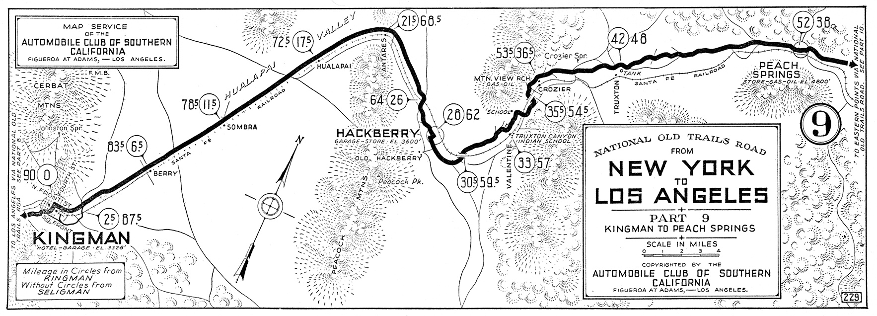
This is ACSC map #229 from Peach Springs, Arizona to Kingman.
— click for larger view —
This is ACSC map #231 from Williams, Arizona to Seligman.
— click for larger view —
This is ACSC map #230 from Seligman, Arizona to Peach Springs.
— click for larger view —
This is ACSC map #229 from Peach Springs, Arizona to Kingman.
— click for larger view —
#17
National Old Trails Road / Re: Williams to Kingman, Arizo...
Last post by Parsa - May 07, 2014, 11:28:22 PMThese maps are from Locke's Good Road Maps of Local and Transcontinental Automobile Routes by Harry Locke.
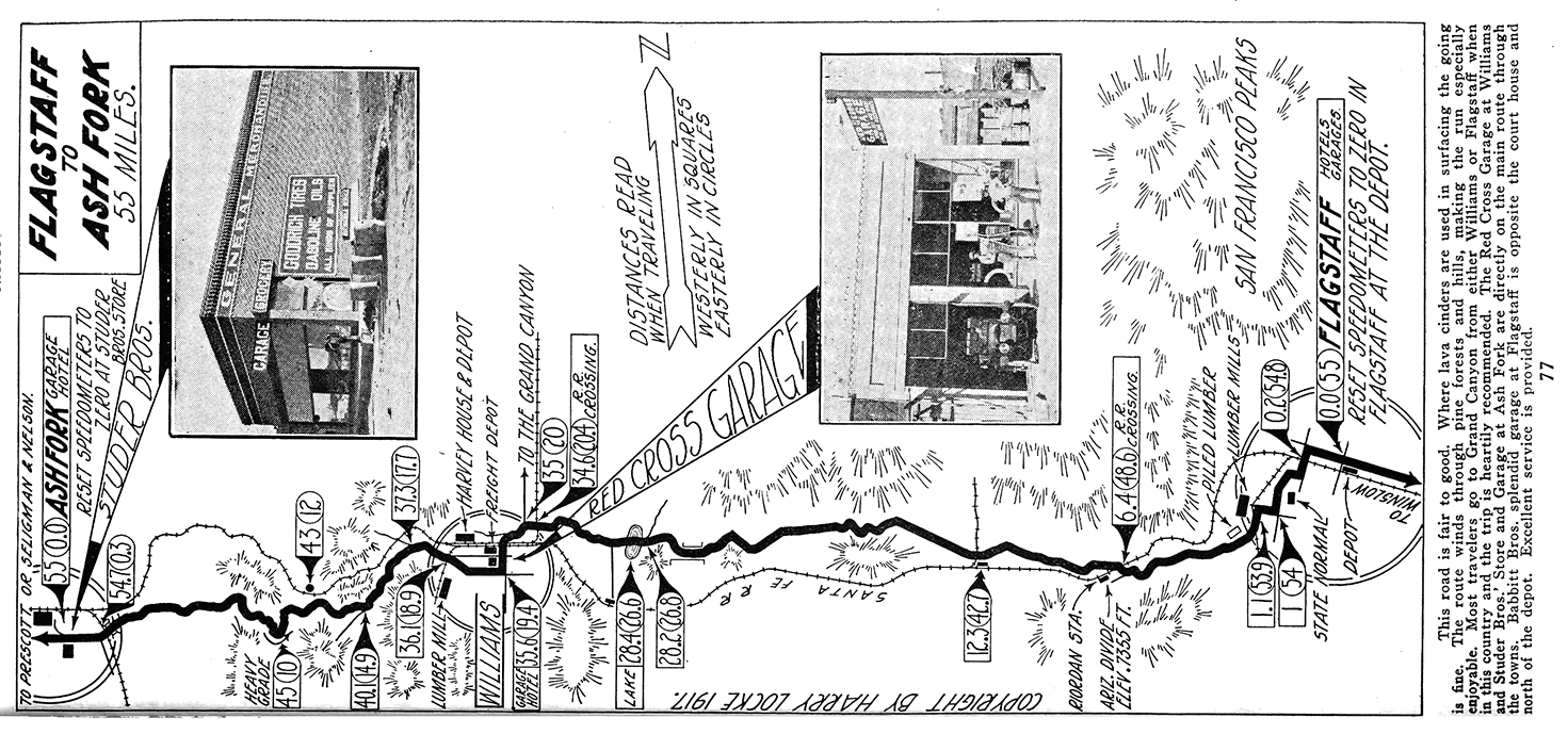
Flagstaff to Ash Fork, 1917.
— click for larger view —
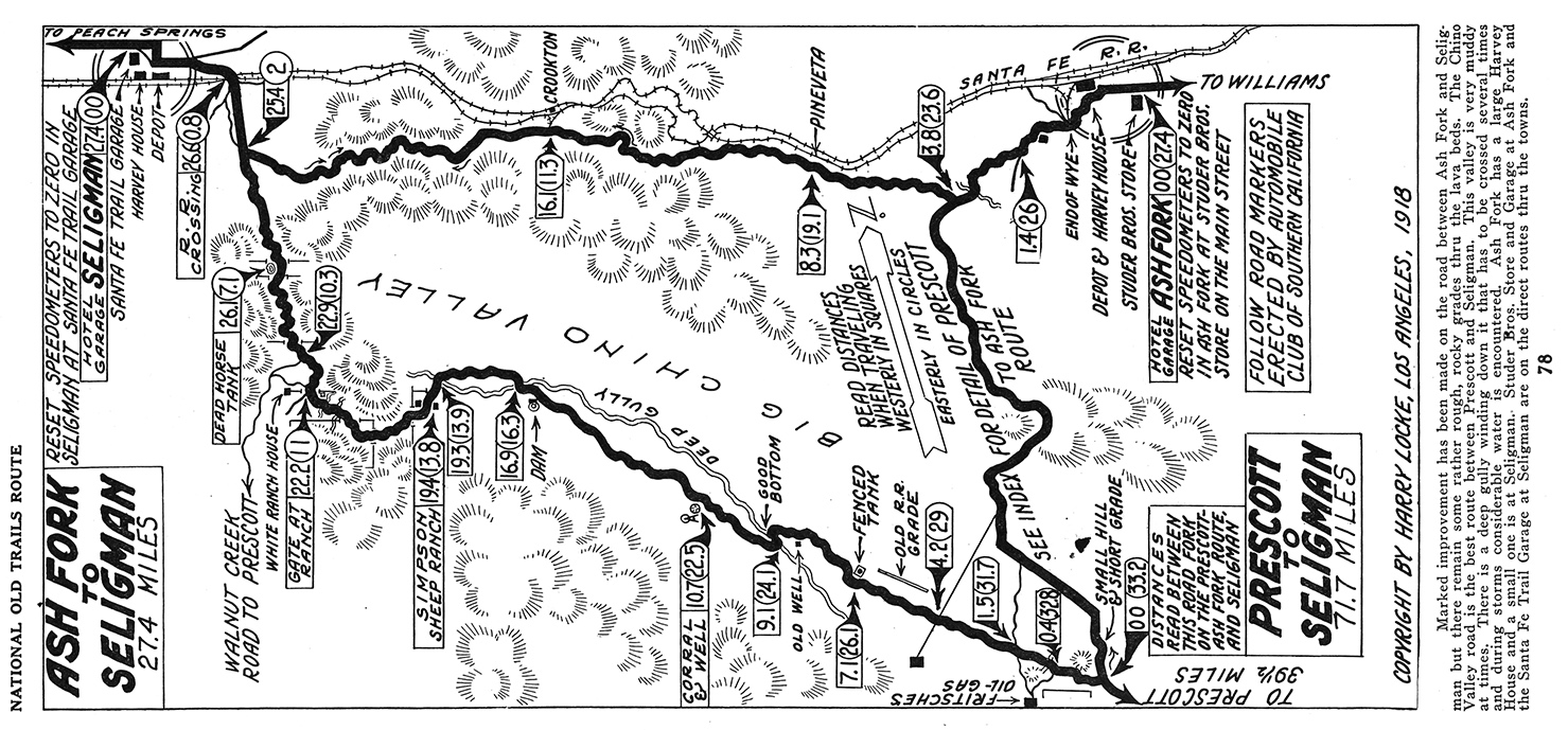
Ash Fork to Seligman, 1918.
— click for larger view —
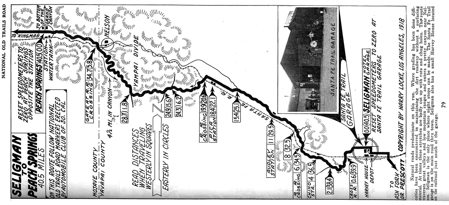
Seligman to Peach Springs, 1918.
— click for larger view —
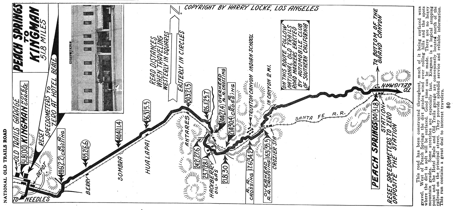
Peach Springs to Kingman, no date — circa 1918.
— click for larger view —
Flagstaff to Ash Fork, 1917.
— click for larger view —
Ash Fork to Seligman, 1918.
— click for larger view —
Seligman to Peach Springs, 1918.
— click for larger view —
Peach Springs to Kingman, no date — circa 1918.
— click for larger view —
#18
National Old Trails Road / Re: Williams to Kingman, Arizo...
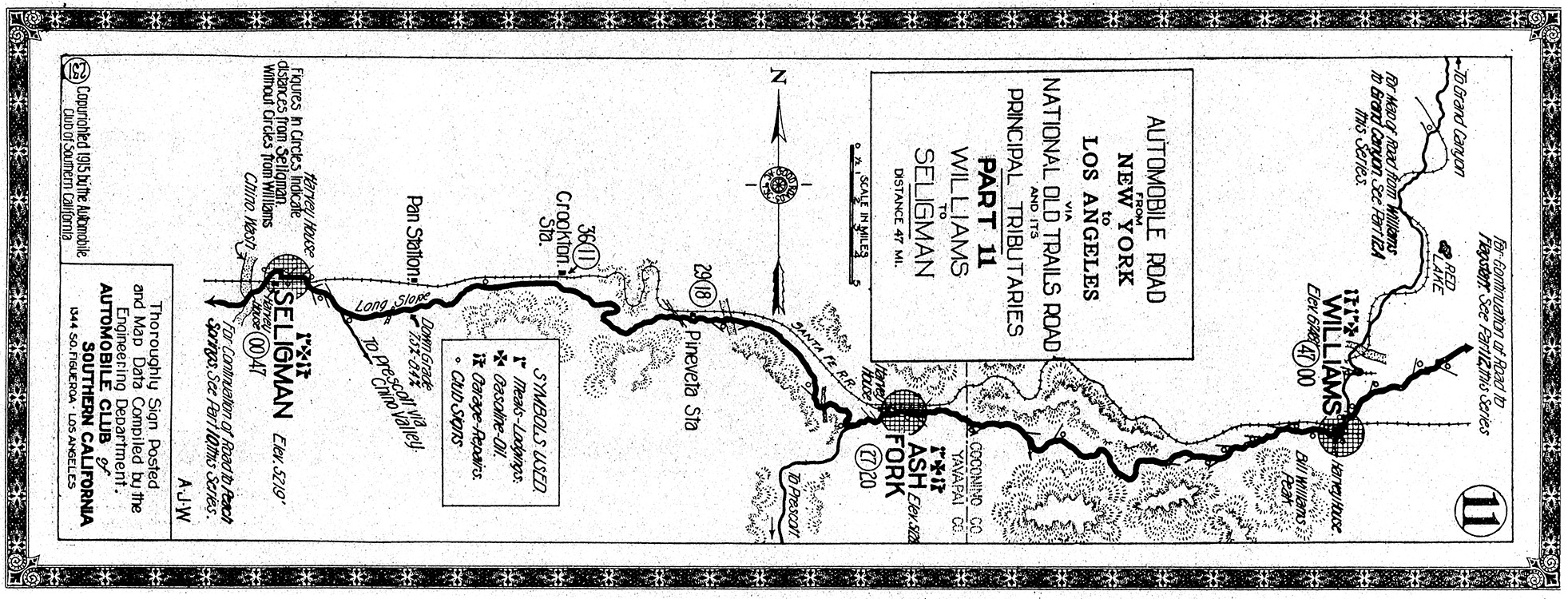
Last post by Parsa - May 07, 2014, 06:53:21 PMThis is NOTR map #231 for Williams to Seligman from the 1915 Automobile Club of Southern California NOTR guide.
— click for large view —
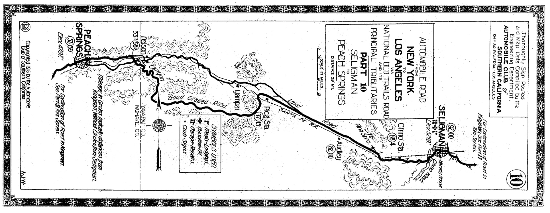
This is NOTR map #230 for Seligman to Peach Springs from the 1915 Automobile Club of Southern California NOTR guide.
— click for large view —
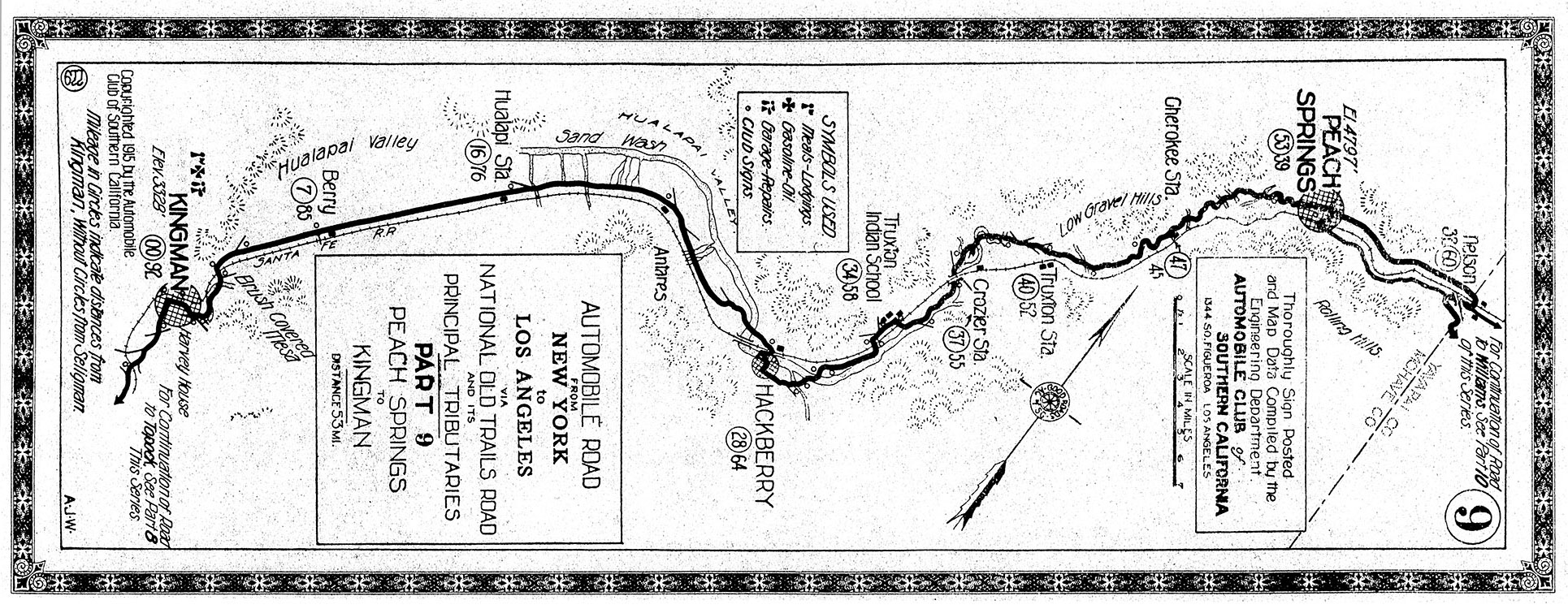
This is NOTR map #229 for Peach Springs to Kingman from the 1915 Automobile Club of Southern California NOTR guide.
— click for large view —
— click for large view —
This is NOTR map #230 for Seligman to Peach Springs from the 1915 Automobile Club of Southern California NOTR guide.
— click for large view —
This is NOTR map #229 for Peach Springs to Kingman from the 1915 Automobile Club of Southern California NOTR guide.
— click for large view —
#19
National Old Trails Road / Williams to Kingman, Arizona
Last post by Parsa - May 07, 2014, 06:44:44 PMThis discussion will be on the NOTR alignments between Williams, Arizona and Kingman to the west.
#20
General American Road Topics / Arizona historic county road m...
Last post by Parsa - January 19, 2014, 07:31:55 PMArizona historic county road maps. Most are the 1937 Arizona General Highway and Transportation maps.
http://azmemory.azlibrary.gov/cdm/search/collection/har/page/1
http://azmemory.azlibrary.gov/cdm/search/collection/har/page/1