- Welcome to American Roads Forum.

Recent posts
#1
Yellowstone Trail / Re: Welcome to the Yellowstone...
Last post by yttrailman - August 19, 2022, 07:18:49 PMPlease refer to the website: www.yellowstonetrail.org
Join the Yellowstone Trail Association and receive the newsletter: The Arrow
Join the Yellowstone Trail Association and receive the newsletter: The Arrow
#2
AmericanRoads.us Web Site / Updates and issues
Last post by Parsa - February 07, 2021, 09:23:50 PMI've updated the forum to the latest SMF version. I also altered several thing related to registration. Many people were registering, but the notifications to me ended up in some email black hole. The registration process has been modified and the emails should be getting to me now.
I've also added links to the top of the forum to make getting back to the main sites easier.
Parsa
I've also added links to the top of the forum to make getting back to the main sites easier.
Parsa
#3
General American Road Topics / Kansas State Highway maps
Last post by Parsa - June 03, 2016, 08:56:51 PMKansas DOT general highway and transportation map for Kansas counties.
http://www.ksdot.org/bureaus/burtransplan/maps/pastpublishedcounty.asp
http://www.ksdot.org/bureaus/burtransplan/maps/pastpublishedcounty.asp
#4
General Auto Trail Topics / Re: Atlantic Pacific Highway (...
Last post by Parsa - May 17, 2016, 05:47:21 PMYes that's the marker. I'm slowly making SVG versions of all the markers for Wikimedia Commons (Wikipedia). I had this one done. Here's a JPEG version. I don't know any history on the highway, but can always look up the route on various auto trail maps. As the name implies, it was transcontinental. As I recall, for a time at least it came to San Diego. I think that changed later to LA.
#5
General Auto Trail Topics / Re: Atlantic Pacific Highway (...
Last post by carl s - March 30, 2016, 09:48:06 AM
A work in progress.
There is so little I've been able to find on this 'highway' I'm not even certain this is the correct road badge.
#6
General Auto Trail Topics / Re: Atlantic Pacific Highway (...
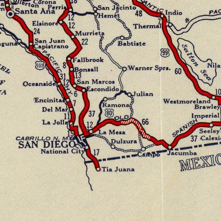
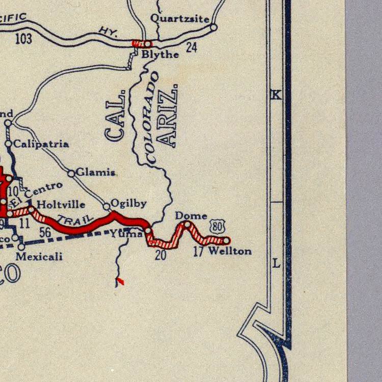
Last post by carl s - March 18, 2016, 10:34:12 PMFirst actual map reference I've been able to find. The full view map shows A&P Hwy from Quartzite through Ehrenberg then Blythe through Chuckwalla Rd to Shaver Summit then through Shaver Canyon and connecting with US 99 at Mecca, cosigned with Us 99 through Indio Coachella Valley Banning Pass to Los Angeles.
<a href="http://www.davidrumsey.com/luna/servlet/detail/RUMSEY~8~1~2159~200005:Rand-McNally-Junior-Road-Map-Califo" rel="nofollow">www.davidrumsey.com/luna/servlet/detail/RUMSEY~8~1~2159~2...</a>
From Jefferson City Post MO - Local Chamber of Commerce
March 7, 1931:
"A letter received by the Chamber of Commerce this morning from H. A. Russell, honorary president of U S. Highway No. 54 Association States that there is great interest- being shown an Kansas and southwestern points in the improvement of ' this highway on account of its new importance as the main highway artery j serving the new vacation 7 land. Rus- isell points out in his letter that U. S. Highway No. 54 from Vaughn, New Mexico to Jefferson City is a part of the Atlantic and Pacific Highway, "the shortest highway with less deserts and less mountains than any other transcontinental highway between New York and Los Angeles." Highway Much Traveled The Atlantic and Pacific Highway is made up of several important U. S. highways, using 50 into Jefferson City from the east, then 54 to Vaughn, New Mexico and U. S. No. 70 from Vaughn west. Inasmuch as U. S. Highway 54 is probably the most important and scenic section of the new transcontinental highway, the association of which Russell is president is strong. ly urging all states through which lit passes to build a concrete highway so that traffic may not be diverted to other concrete highways which do not reach this region of the upper Ozarks. The Chamber of Commerce is cooperating with all cities interested in this new highway and tourist development. LS SFTEfl M Gfll SEDALIA, MO., March 7."
#7
General Auto Trail Topics / Atlantic Pacific Highway (Atla...
Last post by carl s - August 01, 2015, 08:33:35 PMThe Atlantic & Pacific Highway:
Was it just a short lived paper tiger?
Have been unable to gather any significant info - especially for the California segment.
Any help would be welcomed and appreciated.
http://www.davidrumsey.com/luna/servlet/detail/RUMSEY~8~1~2159~200005:Rand-McNally-Junior-Road-Map-Califo
Was it just a short lived paper tiger?
Have been unable to gather any significant info - especially for the California segment.
Any help would be welcomed and appreciated.
http://www.davidrumsey.com/luna/servlet/detail/RUMSEY~8~1~2159~200005:Rand-McNally-Junior-Road-Map-Califo
#8
El Camino Real in California / Re: ECR — La Jolla to Del Mar
Last post by Parsa - July 04, 2015, 01:52:01 PMThe next four maps are from 1915–1917. One source I've read said that Torrey Pines Road was paved in 1915. How far north that paving went is unknown. If it went all the way to La Jolla Junction, then it's possible that Torrey Pines Road became favored over La Jolla Shores Drive and the Biological Grade (aka La Jolla Grade). Some of the maps below, especially the Goodrich map, seem to imply that the grade had been bypassed.
The first map below is the second map I consider as a standard for what the ACSC considered El Camino Real. It is ACSC strip map No. 212, and is part of a second series of three maps entitled "Automobile Tour of the Famous Missions in California on El Camino Real." At this time (before about 1919), the strip maps were still dated. This map has a 1915 copyright date. These maps are also featured in an early ACSC highway guide called California Mission's Tour, dated April 10, 1915. Click for a larger image.
NOTES: Since this is a large scale map showing the route from San Diego all the way to L.A., there isn't a lot of detail. However, the road north from La Jolla seems to go a bit farther east, and there is no indication of the La Jolla Grade as their is for the Torrey Pines Grade. It may just be a lack of detail, but the route bears a resemblance to the next Goodrich map below. No Rose Canyon route is shown.
The map below is from the 1916 Southern California Goodrich Route Book. Click for larger image.
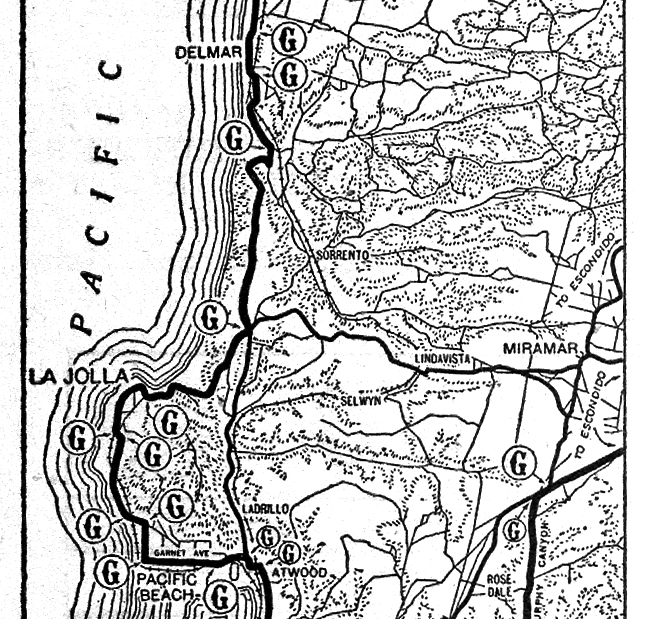
NOTES: Goodrich road signs existed everywhere a "G" is shown on the map.... As mentioned above, the main thing to note here is that the road north from La Jolla seems to be on Torrey Pines Road rather than on La Jolla Shores Drive. The shape of the road, and its position, is nearly identical to the road shown on the topographic maps, as well as most of the road as it exists today. There is definitely no indication of the La Jolla Grade, which exists much closer to the coast. The Rose Canyon road is shown with a medium bold line, indicating a secondary route. It is shown climbing Gilman Drive to La Jolla Junction. The road northeast to Sorrento, and the rest of Sorrento Valley Road is shown, but as a thin line. This map is so close to the road patterns in the topographic maps, that I believe the cartographer used topo maps as a primary resource. One oddity here is the Torrey Pines grade, which still seems to show the old eastward path at the north end of the grade, and the early meeting with Sorrento Valley/Carmel Valley Road.
The third map is a small clip from the 1917 ACSC State of California map.

NOTES: This map also seems to show the same road out of La Jolla as the previous two maps. The Torrey Pines Grade is shown, but the La Jolla Grade is not. The Rose Canyon road is shown, and it seems to head straight north all the way to Sorrento. However, in reality, as stated above, it would have to climb a grade (probably Gilman Drive), and come to at least a quarter mile east of La Jolla Junction. There is no canyon straight north to Sorrento.
The last map is the odd man out. This is from Locke's Good Road Maps of Local and Transcontinental Automobile Routes. This map has a 1917 date, and was first published in the 1917 edition, but my copy is the 1919 edition. Locke's maps have notoriously variable scales, even on the same map. Compass orientations also vary on the same map. However, curves, railroad crossings, stream crossings, etc. are generally indicated where they are often not on other maps.
NOTES: Unlike the other three maps, this map shows the La Jolla grade. The bottom of the Torrey Pine Grade seems to head west to the coast here, and the railroad undercrossing south of Del Mar is clearly labeled. This book recommends a path from San Diego that passes through Point Loma, Ocean Beach, and Mission Beach, rather than the usual path through Old Town, Morena, and Pacific Beach.
The first map below is the second map I consider as a standard for what the ACSC considered El Camino Real. It is ACSC strip map No. 212, and is part of a second series of three maps entitled "Automobile Tour of the Famous Missions in California on El Camino Real." At this time (before about 1919), the strip maps were still dated. This map has a 1915 copyright date. These maps are also featured in an early ACSC highway guide called California Mission's Tour, dated April 10, 1915. Click for a larger image.
NOTES: Since this is a large scale map showing the route from San Diego all the way to L.A., there isn't a lot of detail. However, the road north from La Jolla seems to go a bit farther east, and there is no indication of the La Jolla Grade as their is for the Torrey Pines Grade. It may just be a lack of detail, but the route bears a resemblance to the next Goodrich map below. No Rose Canyon route is shown.
The map below is from the 1916 Southern California Goodrich Route Book. Click for larger image.
NOTES: Goodrich road signs existed everywhere a "G" is shown on the map.... As mentioned above, the main thing to note here is that the road north from La Jolla seems to be on Torrey Pines Road rather than on La Jolla Shores Drive. The shape of the road, and its position, is nearly identical to the road shown on the topographic maps, as well as most of the road as it exists today. There is definitely no indication of the La Jolla Grade, which exists much closer to the coast. The Rose Canyon road is shown with a medium bold line, indicating a secondary route. It is shown climbing Gilman Drive to La Jolla Junction. The road northeast to Sorrento, and the rest of Sorrento Valley Road is shown, but as a thin line. This map is so close to the road patterns in the topographic maps, that I believe the cartographer used topo maps as a primary resource. One oddity here is the Torrey Pines grade, which still seems to show the old eastward path at the north end of the grade, and the early meeting with Sorrento Valley/Carmel Valley Road.
The third map is a small clip from the 1917 ACSC State of California map.
NOTES: This map also seems to show the same road out of La Jolla as the previous two maps. The Torrey Pines Grade is shown, but the La Jolla Grade is not. The Rose Canyon road is shown, and it seems to head straight north all the way to Sorrento. However, in reality, as stated above, it would have to climb a grade (probably Gilman Drive), and come to at least a quarter mile east of La Jolla Junction. There is no canyon straight north to Sorrento.
The last map is the odd man out. This is from Locke's Good Road Maps of Local and Transcontinental Automobile Routes. This map has a 1917 date, and was first published in the 1917 edition, but my copy is the 1919 edition. Locke's maps have notoriously variable scales, even on the same map. Compass orientations also vary on the same map. However, curves, railroad crossings, stream crossings, etc. are generally indicated where they are often not on other maps.

NOTES: Unlike the other three maps, this map shows the La Jolla grade. The bottom of the Torrey Pine Grade seems to head west to the coast here, and the railroad undercrossing south of Del Mar is clearly labeled. This book recommends a path from San Diego that passes through Point Loma, Ocean Beach, and Mission Beach, rather than the usual path through Old Town, Morena, and Pacific Beach.
#9
El Camino Real in California / Re: ECR — La Jolla to Del Mar
Last post by Parsa - July 03, 2015, 02:07:42 PMThe next four maps are all interesting maps fro.m 1914.
The first map is a clip from page 126 of the Fireman's Fund Insurance Company Automobile Tour Book of California. It is dated 1914, but this is actually on a small strip covering a 1913 date. The map in the 1918 edition of the Tour Book is identical to this one. Click for larger image.
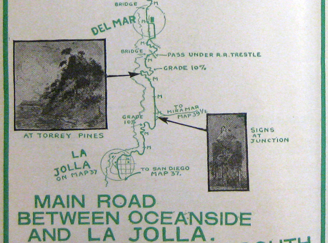
NOTES: The route via Rose Canyon is merely indicated at both ends, not shown in detail. The La Jolla and Torrey Pines grades are shown. The route discussed above to the village of Miramar is indicated with a note. This is the first map to clearly indicate that the road passed under the rail line south of Del Mar. The railroad was on a very large berm at this point. An undercrossing still exists at this location, and is referred to as the McGonigle Road bridge: 32.935402, -117.258386.
The next map is a clip of page 36 from Hamilton's Illustrated Auto Road Map California Tour Book (Fifth edition, 1914). The scale is off on these maps, but they make up for in a lot of added detail. Click for larger image.
An "M" is shown at one mile intervals. Complex curves exist just east of downtown La Jolla. This can be seen in some other maps. The complexity of the La Jolla and Torrey Pines grades are indicated along with percent gradients. La Jolla Junction is shown as a multi-point intersection, which is also shown on topographic maps. A picture of diamond shaped ACSC signs is shown for the junction. The bridge over Los Peñasquitos Creek and the undercrossing at the rail line are shown. Oddly, a second crossing of the rail line is shown before reaching Del Mar. This should be the same rail line, so I couldn't see a a reason why it would cross twice to the east side of the line. I thought it was an error, one left over from the older rail alignment shown on the 1903 topographic map. However, the following maps show two rail lines!
The last two maps are from a very interesting book called 1914–1915 Panoramic Automobile Road Map and Tourist Guide Book of Southern California. The book features an El Camino Real guide post bell on the cover, and there is a hole where a glass marble once existed. The actual book date is 1914, but it's for the 1914–1915 season. The maps are drawings, but are like angled aerial photos. Airplanes are shown flying over many of the maps.
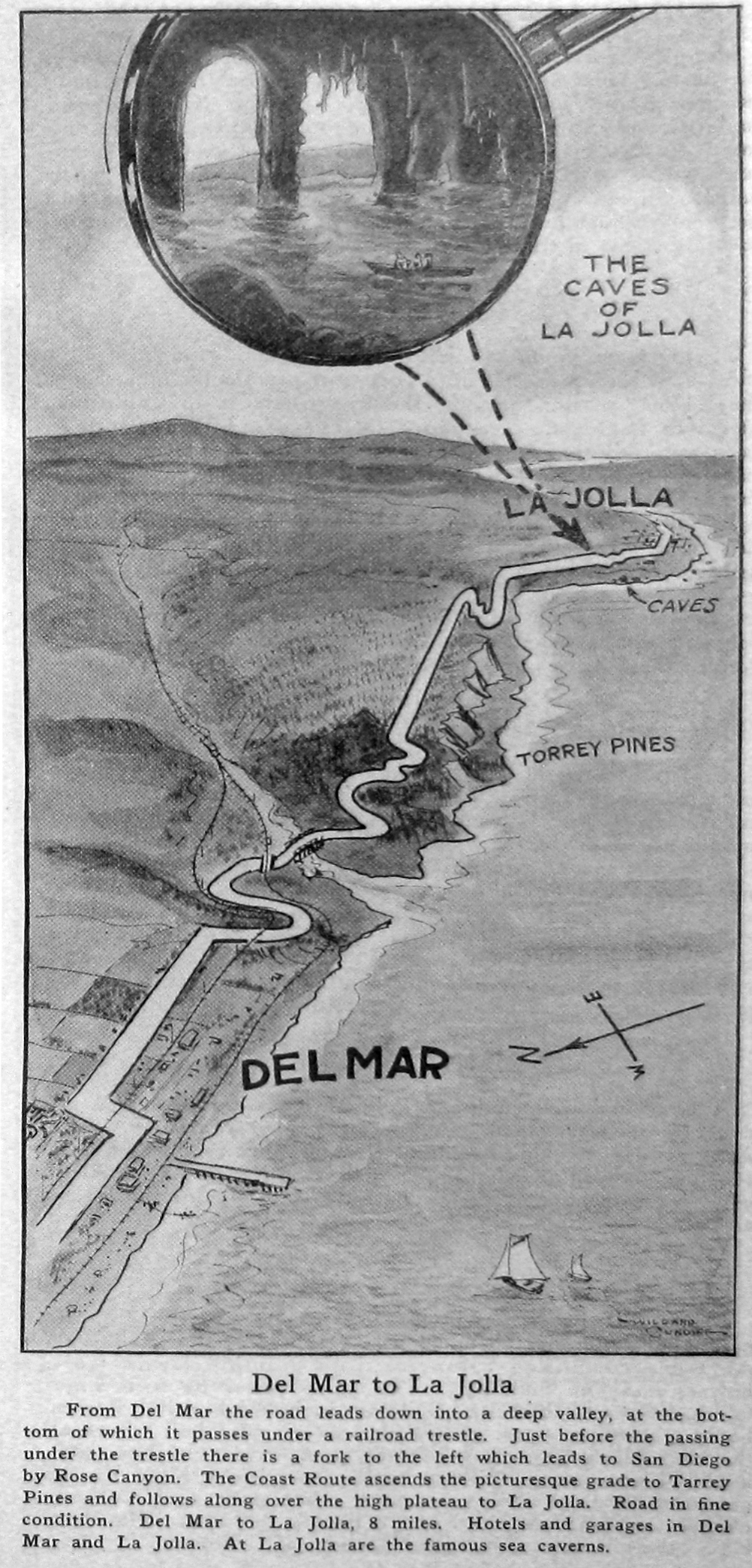
The first map shows the Coast Route from La Jolla to Del Mar. The La Jolla sea caves are featured. The La Jolla and Torrey Pines grades are shown with their topography. The creek bridge and rail undercrossing are shown. After a winding ascent of the Del Mar terrace, a second rail crossing to the east of a second set of tracks occurs before reaching Del Mar. La Jolla Junction is not shown on this map, but is on the next one. Click for larger image.
The second map shows the Rose Canyon ECR route. The ascent to, and descent from, La Jolla Junction is not really shown. Instead, the road seems to continue through a valley. Topographically this is impossible. There is a path that avoids the main La Jolla junction, but by not more than about 0.25 miles to the east. This can be seen in the 1940s topo. The road to Miramar is shown heading east from La Jolla Junction. This route is not even shown on the previous map! Click for larger image.
The first map is a clip from page 126 of the Fireman's Fund Insurance Company Automobile Tour Book of California. It is dated 1914, but this is actually on a small strip covering a 1913 date. The map in the 1918 edition of the Tour Book is identical to this one. Click for larger image.
NOTES: The route via Rose Canyon is merely indicated at both ends, not shown in detail. The La Jolla and Torrey Pines grades are shown. The route discussed above to the village of Miramar is indicated with a note. This is the first map to clearly indicate that the road passed under the rail line south of Del Mar. The railroad was on a very large berm at this point. An undercrossing still exists at this location, and is referred to as the McGonigle Road bridge: 32.935402, -117.258386.
The next map is a clip of page 36 from Hamilton's Illustrated Auto Road Map California Tour Book (Fifth edition, 1914). The scale is off on these maps, but they make up for in a lot of added detail. Click for larger image.
An "M" is shown at one mile intervals. Complex curves exist just east of downtown La Jolla. This can be seen in some other maps. The complexity of the La Jolla and Torrey Pines grades are indicated along with percent gradients. La Jolla Junction is shown as a multi-point intersection, which is also shown on topographic maps. A picture of diamond shaped ACSC signs is shown for the junction. The bridge over Los Peñasquitos Creek and the undercrossing at the rail line are shown. Oddly, a second crossing of the rail line is shown before reaching Del Mar. This should be the same rail line, so I couldn't see a a reason why it would cross twice to the east side of the line. I thought it was an error, one left over from the older rail alignment shown on the 1903 topographic map. However, the following maps show two rail lines!
The last two maps are from a very interesting book called 1914–1915 Panoramic Automobile Road Map and Tourist Guide Book of Southern California. The book features an El Camino Real guide post bell on the cover, and there is a hole where a glass marble once existed. The actual book date is 1914, but it's for the 1914–1915 season. The maps are drawings, but are like angled aerial photos. Airplanes are shown flying over many of the maps.
The first map shows the Coast Route from La Jolla to Del Mar. The La Jolla sea caves are featured. The La Jolla and Torrey Pines grades are shown with their topography. The creek bridge and rail undercrossing are shown. After a winding ascent of the Del Mar terrace, a second rail crossing to the east of a second set of tracks occurs before reaching Del Mar. La Jolla Junction is not shown on this map, but is on the next one. Click for larger image.
The second map shows the Rose Canyon ECR route. The ascent to, and descent from, La Jolla Junction is not really shown. Instead, the road seems to continue through a valley. Topographically this is impossible. There is a path that avoids the main La Jolla junction, but by not more than about 0.25 miles to the east. This can be seen in the 1940s topo. The road to Miramar is shown heading east from La Jolla Junction. This route is not even shown on the previous map! Click for larger image.
#10
El Camino Real in California / Re: ECR — La Jolla to Del Mar
Last post by Parsa - July 03, 2015, 09:32:43 AMThe next three map clips are all from 1912.
The first map clip is from the 1912 American Automobile Association (AAA) strip map No. 65. These were produced by famous auto trail pathfinder Anton Westgard. He was also head of transcontinental mapping. The map is at a 1:250000 scale, and the cartographer's initials are G.W.A. Click for larger image.
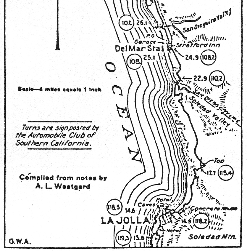
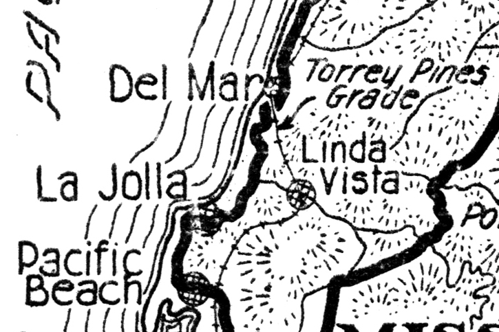
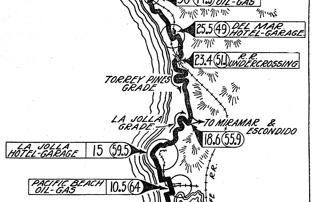
NOTES: This map seems to be the first one where the cartography and scale are fairly precise. The hotel in La Jolla is likely either the La Jolla Park Hotel (1893) or the Hotel Cabrillo (1908), which became part of the historic La Valencia Hotel. The cave store was built between 1902–1912 by Prof. Gustav Schultz. La Jolla Junction is shown at mile 17.7 with the road to Sorrento shown heading northeast. Before this point, the La Jolla (or Biological) grade is shown. There appears to be a difference in the Torrey Pines Grade from earlier maps, and the 1903 topographic map. The road that descends the grade now appears to head west toward the beach rather than east to connect with the Rose Canyon road (Sorrento Valley Road). The road goes almost straight west, then bends 90° north and crosses a bridge, and almost immediately afterward passes under the rail line. Photos of the bridge, the undercrossing, and a discussion of this road can be found on the Del Mar Sandpiper website: "Once there was a wooden bridge." The website says this bridge was built in 1915, but I think this 1912 map shows the same bridge. According to the article, it was good roads activist Ed Fletcher and E.W. Scripps who built the bridge and the Torrey Pines grade. At mile 22.9 the road climbs up Del Mar terrace. There seems to be a sharp right turn inland on top of the terrace. The historic Stratford Inn (now L'Auberge Del mar) is shown. This hotel had a large tudor hotel building on the northwest corner of 15th Street and Grand Avenue, now the south section of Camino del Mar. Camino del Mar did not continue north of 15th. Instead, after passing the hotel, Grand Avenue curved sharply east then west is two switchbacks. After meeting the rail line, it continued northward. A section of old Grand Avenue still exists near the tracks today. However, the coast highway jogged west on 15th, and crossed the rail line on Coast Blvd at a grade crossing that still exists.
The next map is a clip from an unnumbered ACSC strip map entitled "El Camino Real and Popular Automobile Routes to and from Famous Missions South of Los Angeles, Cal." This map, and two others for the northern and central sections of El Camino Real, appeared in the June 1912 ACSC Touring Topics article "Among the Missions on the King's Highway." I consider the maps from this article, and the 1915 "Famous Missions" strip maps, to be the standard for what the Automobile Club considered to be El Camino Real. How close it adheres to the route researched by the El Camino Real Association's route committee is uncertain. Click for larger image.
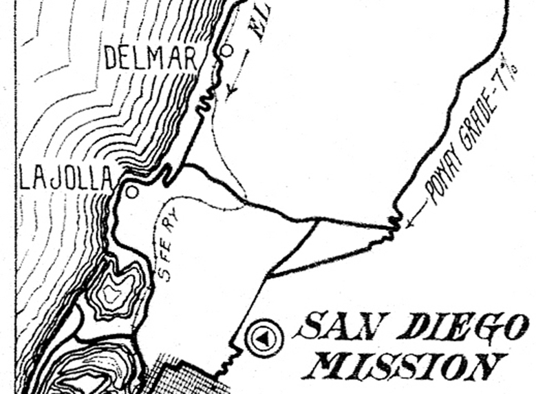
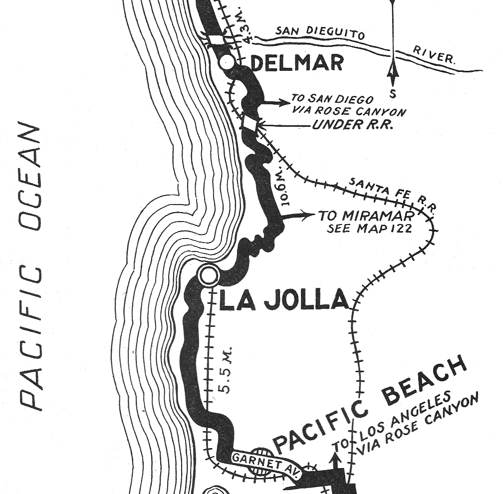
NOTES: This map shows both the Coast Route and the Inland Route (going up the older Poway Grade, today on M.C.A.S. Miramar property). There's not much detail here, but the road is obviously using the la Jolla and Torrey Pines grades. A road connects the Coast and Inland routes where the rail line goes through a deep bend. Today, this route is Eastgate Mall and Miramar Road. The point where this road crossed the rail line was called "Lindavista." Today it is called Miramar siding (32.875796, -117.174833).
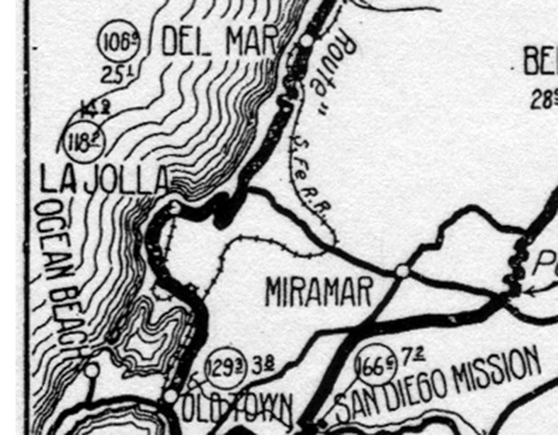
The last map is an early ACSC strip map, No. 78, entitled "Automobile Routes between Los Angeles and San Diego and Connecting Roads." It's pretty large scale, since it shows the whole L.A to San Diego route on one card. The Coast and Inland routes are shown with a bold line. This map is nearly identical in detail to the map above. The road name seen in quotation marks is 'San Diego "Coast Route".' Click for larger image.
The first map clip is from the 1912 American Automobile Association (AAA) strip map No. 65. These were produced by famous auto trail pathfinder Anton Westgard. He was also head of transcontinental mapping. The map is at a 1:250000 scale, and the cartographer's initials are G.W.A. Click for larger image.
NOTES: This map seems to be the first one where the cartography and scale are fairly precise. The hotel in La Jolla is likely either the La Jolla Park Hotel (1893) or the Hotel Cabrillo (1908), which became part of the historic La Valencia Hotel. The cave store was built between 1902–1912 by Prof. Gustav Schultz. La Jolla Junction is shown at mile 17.7 with the road to Sorrento shown heading northeast. Before this point, the La Jolla (or Biological) grade is shown. There appears to be a difference in the Torrey Pines Grade from earlier maps, and the 1903 topographic map. The road that descends the grade now appears to head west toward the beach rather than east to connect with the Rose Canyon road (Sorrento Valley Road). The road goes almost straight west, then bends 90° north and crosses a bridge, and almost immediately afterward passes under the rail line. Photos of the bridge, the undercrossing, and a discussion of this road can be found on the Del Mar Sandpiper website: "Once there was a wooden bridge." The website says this bridge was built in 1915, but I think this 1912 map shows the same bridge. According to the article, it was good roads activist Ed Fletcher and E.W. Scripps who built the bridge and the Torrey Pines grade. At mile 22.9 the road climbs up Del Mar terrace. There seems to be a sharp right turn inland on top of the terrace. The historic Stratford Inn (now L'Auberge Del mar) is shown. This hotel had a large tudor hotel building on the northwest corner of 15th Street and Grand Avenue, now the south section of Camino del Mar. Camino del Mar did not continue north of 15th. Instead, after passing the hotel, Grand Avenue curved sharply east then west is two switchbacks. After meeting the rail line, it continued northward. A section of old Grand Avenue still exists near the tracks today. However, the coast highway jogged west on 15th, and crossed the rail line on Coast Blvd at a grade crossing that still exists.
The next map is a clip from an unnumbered ACSC strip map entitled "El Camino Real and Popular Automobile Routes to and from Famous Missions South of Los Angeles, Cal." This map, and two others for the northern and central sections of El Camino Real, appeared in the June 1912 ACSC Touring Topics article "Among the Missions on the King's Highway." I consider the maps from this article, and the 1915 "Famous Missions" strip maps, to be the standard for what the Automobile Club considered to be El Camino Real. How close it adheres to the route researched by the El Camino Real Association's route committee is uncertain. Click for larger image.
NOTES: This map shows both the Coast Route and the Inland Route (going up the older Poway Grade, today on M.C.A.S. Miramar property). There's not much detail here, but the road is obviously using the la Jolla and Torrey Pines grades. A road connects the Coast and Inland routes where the rail line goes through a deep bend. Today, this route is Eastgate Mall and Miramar Road. The point where this road crossed the rail line was called "Lindavista." Today it is called Miramar siding (32.875796, -117.174833).
The last map is an early ACSC strip map, No. 78, entitled "Automobile Routes between Los Angeles and San Diego and Connecting Roads." It's pretty large scale, since it shows the whole L.A to San Diego route on one card. The Coast and Inland routes are shown with a bold line. This map is nearly identical in detail to the map above. The road name seen in quotation marks is 'San Diego "Coast Route".' Click for larger image.